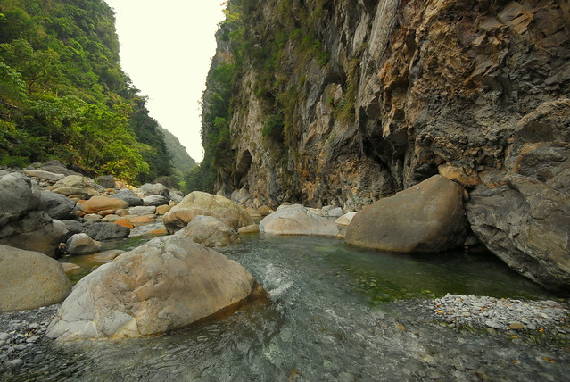
Taroko Gorge
Situated near the rocky east coast of Taiwan, Taroko Gorge is one of the island’s biggest tourist attractions. The canyon is 19 kilometer long and offers a number of different hiking trails through breathtaking scenery of spectacular cliffs and white-water rapids.
Taroko Gorge (太魯閣: Tàilǔgé) [1]) is an impressive 19-km-long canyon, situated near Taiwan's east coast. The area of the gorge is also identified as Taroko Gorge National Park (太魯閣國家公園; Tàilǔgé gúojiā gōngyuán).
The Taroko Gorge is composed mainly metomorphic rocks, such as marble,gneiss, "schist",etc. The name, Taroko, means the "magnificent and splendid" in the language of Truku, the aboriginal tribe who resides in the area.
[edit]History
When Taroko National Park
[2] was eventually established on November 28, 1986, it was of special significance for the environmental protection movement in Taiwan: it showed that both the public and the government agencies had realized despite the nation's four decades of extraordinary economic success, serious damage was being done to its natural resources. According to the National Park Act of the Republic of China (passed in 1972), parks are established to protect the natural scenery, historic relics and wildlife; to conserve natural resources; and to facilitate scientific research and promote environmental education.
[edit]Landscape
The most phenomenal aspect of the park is the amazing relief. In a single afternoon you can travel from rugged coastal cliffs through a maze of subtropical forested canyons to high elevation subalpine coniferous forests.
In about 60 kilometers the landscape rises from sea level to some of the tallest peaks in Taiwan at over 3400 meters. That's steep!
The force behind the steep valleys and narrow canyons is a (geologically speaking) relatively fast rate of uplift combined with ample water. Over the last 70 million years, these two forces collaborated to form the world's deepest marble canyon. The slot canyons here are remarkable with narrows sections a thousand feet high and only a dozen yards apart, reminiscent of the Virgin River in Zion National Park in Utah, USA. Ignore the fact that Zion is in the desert, and made of sandstone and Taroko is subtropical and comprised of marble, and these two gorges have a lot in common.
[edit]Flora and fauna
The park has 144 species of birds 10 percent of which are indigenous to Taiwan. It also hosts over 30 large species of mammal including deer, boar, and bear. 251 species of butterflies, 32 species of reptile and 18 species of fish are also known but considering the rugged terrain of the park, this is probably only a fraction of the species that actually live in the park.
[edit]Climate
The climate is subtropical and generally mild. Rainfall is abundant year round so be prepared and be especially cautious about entering the gorge during typhoons or periods of extended heavy rain due to the danger of landslides and rockfall.
According the the Taiwan Central Weather Bureau, average temperatures at low elevations in the park range from 14 degrees Celsius in January to 27 degrees Celsius in July. At higher elevation it is much cooler with winter temperatures at 2000 meters being about 5.5 degrees C in the winter and 17.5 degrees in the summer and at 3400 meters at the top of Hehuan, temperatures average -3 in January and 9 in July.
The nearest major city is
Hualien. Flights and trains are available from Taipei and most major cities.
From
Hualien, bus departs from the train station at 6.30am (to Luoshao), 8.40am (to Lishan), 10.50am (to Tiansiang) and 1.50pm (to Tiansiang). After that, no bus is running anymore. All buses stop at Tzuchi Vihara, Sincheng Taroko Station (太魯閣火車站), Taroko Visitor Center (park entrance), Shakadang (砂卡礑) and Buluowan (布落灣). Although the distance is not large, this bus should take at least 2 hours to Tiansiang, due to very frequent stops and reduced speed inside the gorge. Price: about 170NTD. No change is given, so be sure to bring the exact amount.
In 2010, the Taiwan Tourism Office began running a Tour Taiwan (台灣好行) Taroko Bus departing from Hualien train station, stopping at Sincheng station, Taroko Tourist Information Centre (太管處), Shakadang Trail (砂卡礑), Buluowan (布洛灣), Swallows Grotto (燕子口), Tunnel of Nine Turns (九曲洞), Lushui (合流.綠水) and finishing at Tiansiang (天祥). The service is free until the end of 2010. On weekdays, there are 8 buses per day, departing from 6.50am from Hualien with last bus leaving Hualien at 3:00pm. From Tiansiang to Hualien, buses begin at 8:20am with last bus leaving Tiansiang at 4.30pm. The buses run hourly [
http://www.taroko.gov.tw/English/?mm=5&sm=3&page=4#up ]. Additional services run on weekends. The Tour Taiwan bus stops are red in colour with the 'Tour Taiwan' logo. They are placed in prominent locations at the pick up/drop off locations. Make sure you are standing on the right side of the road and hail at the bus if you wish to get on.
In 2011, this service seems to have been discontinued. In 2012, this service has been resumed. 1-day unlimited pass is NT$250, 2-day unlimited pass is NT$400. As of October 15, 2012, Shakadang Trail and Tunnel of Nine Turns have been closed due to typhoon damage; it is a good idea to ask the information center about a good tour path.
[edit]By train
A journey by train from
Taipei to
Hualien takes 2 hours by express train (440NTD) and 3 to 4 hours by local trains. The trains are cheap, reliable and comfortable. Station names are announced in English and Chinese so you should have no problem identifying your stop. The closest train station to the park entrance is
Sincheng (新城). From there, there is the choice of a one way taxi ride from the station to Taroko for about NT$200 or a day tour costing about NT$2,000.
The Tour Taiwan (台灣好行) Taroko Bus picks up and drops off at both Singcheng (新城) station and Hualien station.
[edit]By taxi
A taxi from the Hualien train station to Tiansiang (town in Taroko National Park, where the Grand Formosa hotel is located) costs about NT$1200 and takes about 1 hour.
[edit]By scooter
You can rent a scooter near the train station in Hualien. It takes around 30min to reach Taroko Gorge. However in some cases you may need a local drivers license to do so. You can also rent a scooter by the Xincheng train station, which is closer to the park. The price quoted in April 2012 was NT$500 per day. An American or European drivers license (and possibly other countries as well) and a passport will suffice at this shop.
[edit]Fees/Permits
Entry to the park is free but if you want to go to some of the wilderness or into areas designated as Eco-protection areas or restricted mountain areas, you will need an entry permit. Be sure to apply for the permits early (at least 1 week before) as some permits are limited by a small number per day. Refer to the official Taroko National Park information website for application procedures:
http://www.taroko.gov.tw/English/
[edit]Get around
There are numerous bus tours visiting the gorge every weekend. And, while the buses are comfortable and air-conditioned, the tours tend to have a tight itinerary (including, of course, the obligatory stop at some local gift shop), leaving little time for extended hiking. Tour buses leave from the
Hualien visitor information center and cost about NT$988 per person for a whole day tour.
There is also a non-tourist bus that brings passengers to and from Tiansiang. However, it goes pretty fast around some sharp turns along steep cliffs. If you get car sick easily or are afraid of heights, you might want to pass on this bus. From Tiansiang, buses depart to inside the gorge at 8am to LuoShao (洛韶) and 10.05 to
LiShan (梨山). Starting from Tiansiang (169.5km of highway 8; altitude: 480m), the bus to Lishan runs through Wenshan (167km, 575m), Huitouwan (163.4km, 750m), Xibao (161.4km, 915m), Luoshao (洛韶, 154km, 1117m), Xinbaiyang (143km, 1644m), Ci'en (132.8km, 1995m), Bilü Sacred Tree (128.3km, 2150m), Guanyuan (117.3km, 2374m), Dayuling (112.5km, 2565m), Lishan (1800m). The bus to Lishan arrives there at 1pm, and departs from Lishan to Tiansiang at 3pm. Buses from Tiansiang depart to
Hualien at 9.10, 14.00, 16.40 and 18.00. Price: about 170NTD. Don't forget to bring enough coins as no change is given.
There is (or has been?) also a free shuttle bus which you can take from outside the Visitors Centre near the Train station. This runs all the way to Tiansiang and you can get off and on at about 10 stops. The timetable is available from the Visitor's Centre. It runs approximately every hour from about 8:00 to 17:00 [though not on the hour]. There are a few extra services at weekends. This bus does not seem to run in 2011. This bus has started running again in 2012 but gets fairly crowded at the end of the day when everyone wants to leave. It costs NT$250 for a 1-day unlimited use pass or NT$400 for a 2-day pass.
Renting a car in Hualien is definitely an option, though be very cautious; the roads through the gorge are extremely narrow with numerous bends. In addition, there are pedestrians, scooters, cars and massive tour buses all vying for the tight space.
[edit]By scooter
The Gorge is not the best place for a first scooter experience. However, it's a fantastic place to ride for those with experience. Scooters are available to rent in Hualien. If you run low on fuel, the locals often stock a small supply that they'll part with for a miraculously uninflated price. There is also a gas station 50km passed Taroko on the number 8 road (around kilometer 118). The drive there climbs to an impressive 3 km altitude. Bring warmer clothes and rain gear. Also make sure to get a helmet with a rain visor. You can rent a scooter from Pony near the train station in Hualien (around NT$400/day)
[edit]By bicycle
For the truly adventurous, cycling is a wonderful way to traverse the park.You can rent a bike just in front of the entrance of the Taroko national park. It costs NT$250 for a day.
If you do not have any of the above you can see some parts of the national park by foot. The closest hiking trail to the park entrance is the Shakadang Trail, which departs from the road after the first tunnel approximately 1 km from the park headquarters. The eternal spring shrine is only 1.4 km further trough the tunnels. Taking this tour takes about 4-5h, don't forget to take enough water with you.
[edit]By hitchhiking
Although
Taiwan is not a hitchhiking paradise, it is pretty easy to hitchhike in the Taroko gorge and, more generally, on Highway 8, especially if you are a foreigner.
- The Eternal Spring Shrine (長春祠)
Drive from the west exit of the Changchun Shrine Tunnel of Central Cross-Island Highway, then turn south to Liwu River Valley, you can see the Changchun Shine (Eternal Spring Shrine) which recognizes the personnel died during the construction of Central Cross-Island Highway. Rivers adjacent to the Changchun Shine become the scattering falls, and the Highway Bureau named it after "Chanchun Falls" which is now the significant landmark on Central Cross-Island Highway.
In 1987 the cliffs of the rivers tumbled and destroyed the pavilion nearby the Changchun Shine. After 10 years it has been restored and now open to the public agagin. In the back of the Changchun Shine , there are stairs leading to Kuanyin Caves, Taroko Tower , Bell Tower , and through a hanging bridge, so called "Heaven trail" to Changuang Temple. The river valley next to the Changuang Temple has a calabash shape, and it is named thereafter as Calabash Valley (Hu-lu Gu).